







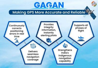
India’s indigenous GPS Aided GEO Augmented Navigation (GAGAN) system has emerged as a key pillar of the country’s satellite navigation ecosystem, enhancing flight safety through precision navigation while expanding its applications across sectors including transport, disaster management, defence and telecommunications.
Developed jointly by the Indian Space Research Organisation (ISRO) and the Airports Authority of India (AAI), GAGAN is a Satellite-Based Augmentation System (SBAS) that improves the accuracy of Global Positioning System (GPS) signals by providing real-time corrections and integrity information to aircraft.
Operational since 2015, GAGAN has placed India among a select group of countries with an operational SBAS, alongside the United States, Europe and Japan. It is also the first SBAS certified for operations in the equatorial region.
The system achieved a major milestone in June 2026, when the Directorate General of Civil Aviation (DGCA) successfully conducted India’s first satellite-based landing approach on a commercial aircraft using GAGAN technology.
GAGAN functions through an integrated network comprising 15 Indian Reference Stations, two Master Control Centres, three Land Uplink Stations, four communication networks, and three geostationary satellites—GSAT-8, GSAT-10 and GSAT-15—equipped with GAGAN payloads. Together, these monitor GPS signals, calculate corrections and broadcast enhanced navigation information across the Indian Flight Information Region.
The system complements Navigation with Indian Constellation (NavIC), India’s indigenous regional navigation satellite system. While NavIC provides positioning, navigation and timing services, GAGAN enhances GPS signals to enable precision aircraft navigation and satellite-based landing operations.
Built in line with international civil aviation standards, GAGAN is interoperable with global augmentation systems, including the United States’ Wide Area Augmentation System (WAAS), Europe’s European Geostationary Navigation Overlay Service (EGNOS) and Japan’s Multi-functional Satellite Augmentation System (MSAS).
Beyond aviation, GAGAN supports a range of civilian and strategic applications. These include maritime navigation, intelligent road transport systems, railway operations, disaster management, defence navigation, telecommunications, and high-precision surveying and mapping.
The government said GAGAN, alongside NavIC, will continue to strengthen India’s indigenous navigation capabilities, improve air traffic management and reduce dependence on foreign navigation systems. With expanding applications across multiple sectors, the system is expected to play a significant role in advancing the country’s vision of a connected, self-reliant and technology-driven future.